Accès aux soins en Afrique : pourquoi cartographier les établissements de santé peut sauver des vies
Life‑Saving Maps: Why Mapping Healthcare Access in Africa Is Critical
Life‑Saving Maps: Why Mapping Healthcare Access in Africa Is Critical

Published: July 21, 2025
Table of Contents
- Overview
- Why Map Health Facilities?
- Key Data Elements
- How to Build a Health Facility Database
- Life‑Saving Impacts
- Persistent Challenges
- Recommendations
- Resources & Further Reading
Overview
During the COVID‑19 pandemic, the lack of reliable information on healthcare facilities in sub‑Saharan Africa became a glaring challenge. Health ministries, public health officials, and development partners struggled to identify facilities with available beds, oxygen, or specialists exactly when demand rose sharply.
Mapping every clinic and hospital—where they are located, what they offer, and how well equipped they are—can transform responses in real time and ensure equitable access to care across the continent.
Why Map Health Facilities?
Comprehensive healthcare maps allow:
- Public awareness: Individuals can find nearby clinics or hospitals offering maternal care, emergency services, or oxygen support.
- Resource planning: Authorities can deploy staff, supplies, or mobile clinics strategically, as seen in Sierra Leone and Mali during Ebola and COVID‑19 responses.
- Pandemic preparedness: During COVID‑19, facility lists helped governments allocate isolation wards and oxygen concentrators efficiently.
- Targeted outreach: Community health workers and vaccination teams rely on facility maps to plan door‑to‑door campaigns and outreach zones.
Key Data Elements to Include
An effective health facility database includes:
- Unique identifier: A code to avoid duplicates
- Name and ownership: Public, private or NGO-run
- Service level: Primary, secondary or tertiary
- Capacity: Number of beds, staff, oxygen units
- Services offered: Obstetrics, ICU, malaria treatment
- Location data: GPS coordinates plus district identifiers
- Contact info: Phone, email, latest update date
- Status: Operational, closed, or repurposed
How to Build a Health Facility Database
There are two primary methods:
- Facility census: A nationwide door‑to‑door survey, like Kenya completed in 2023. It provides the most accurate data but requires significant investment.
- Composite lists: Combining existing records from past surveys, donor programs, and facility registries—as Senegal and Kenya did in earlier years.
The finished database should be publicly accessible via web portals so stakeholders—including ministries, NGOs, researchers, and communities—can easily view and update information.
Life‑Saving Impacts Across Africa
Well‑maintained healthcare maps have saved lives. In emergency situations, authorities can quickly locate ICUs or maternity wards when seconds matter. In Africa, mapping helped:
- Deploy oxygen generators during COVID‑19 hotspot surges.
- Guide vaccination teams to underserved regions for measles and polio.
- Direct NGO support to regions lacking FGM aftercare clinics or infant resuscitation units.
During epidemics or natural disasters, such maps also aid cross-border coordination—crucial in regions with shared health risks, like the Sahel and Great Lakes.
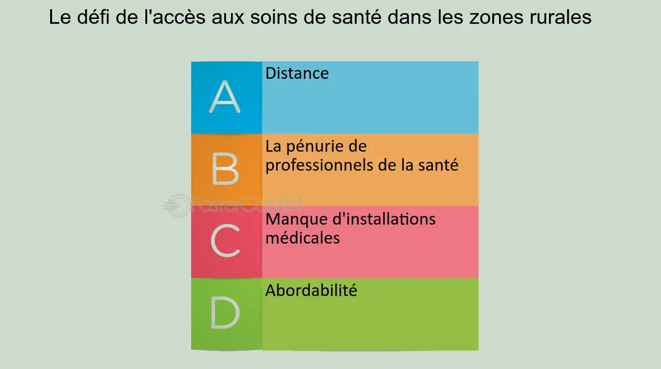
Persistent Challenges
- Data gaps & duplication: In Nigeria and Tanzania, multiple lists produced by different agencies often conflicted and were never harmonized.
- Lack of updates: Without dedicated budget or personnel, facility data becomes outdated quickly.
- Technical limitations: Many rural areas still lack connectivity or GIS capacity for digital mapping.
- Governance issues: Ministries must own and lead the process to ensure sustainability and trust.
Recommendations for a Sustainable Strategy
- Secure government leadership through clear policies and funding.
- Leverage partnerships with NGOs, universities, and donor agencies.
- Train local staff on data collection and GIS management.
- Publish the database in open formats under privacy-compliant protocols.
- Commit to periodic updates and encourage community feedback.
Resources & Further Reading
Life‑Saving Maps: Why Mapping Healthcare Access in Africa Is Critical
Life‑Saving Maps: Why Mapping Healthcare Access in Africa Is Critical
Published: July 21, 2025
Table of Contents
- Overview
- Why Map Health Facilities?
- Key Data Elements
- How to Build a Health Facility Database
- Life‑Saving Impacts Across Africa
- Persistent Challenges
- Innovations in Healthcare Mapping
- Recommendations for a Sustainable Strategy
- Resources & Further Reading
Overview
During the COVID‑19 pandemic, the lack of reliable information on healthcare facilities in sub‑Saharan Africa became a glaring challenge. Health ministries, public health officials, and development partners struggled to identify facilities with available beds, oxygen, or specialists exactly when demand rose sharply.
Mapping every clinic and hospital—where they are located, what services they offer, and how well equipped they are—can transform responses in real time and ensure equitable access to care across the continent. This need for accurate healthcare data extends far beyond the pandemic, influencing how health emergencies, routine care, and vaccination campaigns are conducted.
Why Map Health Facilities?
Comprehensive healthcare maps allow governments, NGOs, and communities to:
- Inform Public Awareness: Individuals and families can identify the closest facilities offering essential healthcare services such as maternal care, emergency treatment, and chronic disease management.
- Optimize Resource Allocation: Health authorities can strategically deploy healthcare workers, medical supplies, and emergency resources to areas of greatest need, minimizing wastage and reducing inequalities.
- Enhance Emergency Response: During epidemics or natural disasters, detailed facility maps enable rapid identification of equipped hospitals, ensuring that patients are transported to appropriate care centers without delay.
- Support Vaccination and Outreach Campaigns: Health facility databases assist in planning targeted vaccination drives and community health interventions, improving coverage and outcomes.
- Enable Policy and Research: Researchers and policymakers use health facility data to analyze healthcare access disparities, design equitable interventions, and monitor progress toward universal health coverage.
Key Data Elements to Include
For healthcare facility mapping to be effective, certain critical data points must be collected and maintained:
- Unique Identifier: Assigning a unique code to each facility prevents duplication and confusion across datasets.
- Facility Name and Ownership: Identifying whether the facility is public, private, or NGO-run aids in understanding service availability and funding sources.
- Service Level and Type: Categorizing facilities as primary, secondary, or tertiary care centers clarifies the scope of services provided.
- Capacity Metrics: Number of hospital beds, availability of oxygen cylinders or ventilators, and specialist staff numbers.
- Services Offered: Including maternal health, emergency obstetrics, intensive care, laboratory services, and pharmacy availability.
- Geographical Location: GPS coordinates and administrative divisions (district, region) for precise mapping and jurisdictional purposes.
- Contact Information and Operational Status: Current phone numbers, emails, and whether the facility is open or temporarily closed.
- Date of Last Update: Ensures data is current and reliable.
How to Build a Health Facility Database
Developing a comprehensive and accurate healthcare database requires a combination of methods:
- National Facility Census: This involves a door-to-door survey of all health facilities within a country, as successfully conducted by Kenya in 2023. Though resource-intensive, this approach provides the most accurate and complete data.
- Integration of Existing Records: Many countries begin by compiling existing databases from various ministries, NGOs, and international agencies. While often incomplete or inconsistent, integration efforts—as done in Senegal—can build a foundational database.
Post data collection, the database should be maintained as a centralized, publicly accessible portal. Transparency and ease of access encourage continuous data updates and foster collaboration among healthcare providers, researchers, and policymakers.
Life‑Saving Impacts Across Africa
Healthcare facility maps have significantly improved health outcomes in many African countries. Notable impacts include:
- Enhanced Pandemic Response: In the COVID‑19 crisis, governments could rapidly identify hospitals with ICU capacity and oxygen availability, allowing for targeted resource distribution.
- Improved Maternal and Neonatal Care: Mapping helped allocate emergency obstetric care services in underserved rural areas, reducing maternal mortality rates.
- Informed Vaccination Campaigns: Detailed health facility data enabled microplanning for immunization drives against diseases like measles, polio, and now COVID‑19.
- Strengthened Disease Surveillance: Real-time data from mapped facilities feeds into early warning systems for outbreaks, helping to contain epidemics swiftly.
- Cross-Border Health Cooperation: In regions like the Sahel, coordinated facility mapping across borders has improved pandemic preparedness and emergency medical services.
Persistent Challenges
Despite progress, several hurdles remain:
- Data Fragmentation: Countries like Nigeria and Tanzania have multiple, often conflicting lists maintained by different agencies, leading to confusion and inefficiencies.
- Inadequate Funding: Governments often lack sufficient resources for regular updates, leading to outdated data that compromises planning.
- Technological Limitations: Poor internet connectivity and lack of geographic information system (GIS) expertise limit the ability to maintain and use digital health maps effectively.
- Governance and Coordination: Without clear ownership and leadership by Ministries of Health, healthcare databases may become siloed or politicized.
- Privacy Concerns: Balancing open access with protection of sensitive data, especially patient-related information, remains a complex issue.
Innovations in Healthcare Mapping
Recent advances are revolutionizing healthcare mapping in Africa:
- Mobile Data Collection: Smartphones and tablets enable real-time updates from remote facilities, enhancing data accuracy.
- Open-Source Platforms: Tools like Healthsites.io provide free, collaborative platforms for mapping and sharing healthcare data globally.
- AI and Satellite Imagery: Emerging use of AI algorithms and satellite data improves estimation of health facility coverage and infrastructure quality.
- Community Engagement: Crowdsourced data collection empowers local communities to report on facility status and needs.
- Interoperability Standards
: The adoption of standards like HL7 and FHIR ensures that healthcare data systems can communicate seamlessly, improving integration across health ministries, NGOs, and international platforms.
These innovations offer new hope for building resilient healthcare systems that are responsive, transparent, and equitable—especially in low-resource settings.
Recommendations for a Sustainable Strategy
- Government Commitment: Ministries of Health must lead healthcare mapping initiatives with clear mandates, funding, and governance structures.
- Partnership Development: Collaboration with humanitarian organizations, research institutes, and private sector partners is vital for data collection, verification, and maintenance.
- Capacity Building: Invest in training programs for local health workers and data managers on GIS tools, digital literacy, and database maintenance.
- Open Access Policies: Adopt open data policies with proper anonymization protocols to ensure security and transparency.
- Continuous Monitoring: Establish a system for regularly updating health facility data to reflect closures, expansions, or changes in service delivery.
Only with sustained political will, community involvement, and global cooperation can Africa achieve the goal of equitable, data-informed healthcare delivery.
Resources & Further Reading
- Healthsites.io – Open Health Facilities Database
- WHO Global Health Facility Data
- HIFLD GeoPlatform
- Global Health 2035 Report
- Read also: Africa’s Healthcare Strategy for 2025
Vital Innovation: Mapping Healthcare Access in Afrique to Save Lives
Vital Innovation: Mapping Healthcare Access in Afrique to Save Lives
Published: July 21, 2025
Table of Contents
- Overview of Mapping Needs in Afrique
- Why Map Health Facilities in Afrique?
- Essential Data Elements
- Methodologies for Collection in Afrique
- Real‑World Impact Across Afrique
- Challenges Facing Afrique Health Mapping
- Innovations in Healthcare Mapping in Afrique
- Recommendations for Afrique Stakeholders
- References
Overview of Mapping Needs in Afrique
During the COVID‑19 pandemic, gaps in accurate information about healthcare facilities across sub‑Saharan Afrique became urgently clear. Policymakers, NGOs, and healthcare providers lacked access to real-time data on bed capacity, oxygen availability, or specialist care. Mapping healthcare facilities across Afrique—including size, location, services, and infrastructure—has since emerged as a vital tool for crisis response and planning.
Why Map Health Facilities in Afrique?
Mapping health facilities across Afrique enables:
- Public access to care information: Individuals can locate nearby clinics or hospitals offering emergency, maternal, or specialist care.
- Efficient resource allocation: Authorities can direct funding and supplies to the areas most in need across Afrique.
- Improved pandemic readiness: Facility maps allowed governments in Afrique to target ICU deployment and oxygen distribution during COVID‑19.
- Enhanced outreach planning: Vaccination and community health initiatives in Afrique rely on accurate maps to plan coverage.
- Policy and research planning: Facility mapping supports monitoring of access inequities and planning of national health systems across Afrique.
Essential Data Elements
An effective healthcare facility dataset in Afrique should include:
- Unique facility ID
- Name, ownership (public/private/NGO)
- Facility classification: primary, secondary, tertiary
- Capacity (beds, oxygen units, staff)
- Services offered (maternal care, ICU, diagnostics)
- Exact geolocation (GPS coordinates, administrative region)
- Contact & operational status
- Last update date
BMC Medicine research emphasizes that inclusion of both public and private facilities, as well as services and capacity, is essential for comprehensive planning across Afrique :contentReference[oaicite:1]{index=1}.
Methodologies for Collection in Afrique
Facility data in Afrique can be collected through:
- National facility census: Like Kenya in 2023, door‑to‑door enumeration captured both public and private facilities :contentReference[oaicite:2]{index=2}.
- Integration of existing records: Countries like Senegal and Kenya updated older databases into centralized accessible datasets.
- Open‑source platforms: Tools such as Healthsites.io integrate crowdsourced OSM data and official records across Afrique :contentReference[oaicite:3]{index=3}.
- Spatial accessibility modeling: Studies comparing costs-distance and Euclidean models in 12 countries reveal insights about rural vs urban perceived access :contentReference[oaicite:4]{index=4}.
Real‑World Impact Across Afrique
Healthcare mapping has generated life-saving benefits across Afrique:
- During COVID‑19, governments identified facilities with ICU or ventilators for targeted interventions.
- Mapping enabled maternal and neonatal emergency care in underserved zones, reducing mortality.
- Vaccination efforts in Nigeria, Sierra Leone, and Mali used maps to plan door‑to‑door campaigns and close coverage gaps :contentReference[oaicite:5]{index=5}.
- Disease surveillance systems, supported by facility data, improved early detection during Ebola and Lassa fever outbreaks :contentReference[oaicite:6]{index=6}.
Challenges Facing Afrique Health Mapping
- Fragmented and outdated data: Nigeria and Tanzania previously held competing facility lists, with duplication and inconsistent data :contentReference[oaicite:7]{index=7}.
- Insufficient funding and infrastructure: Regular updates are rare in low-resource settings across Afrique.
- Technical and connectivity limitations: Limited GIS capacity hinders maintenance of digital facility maps.
- Governance gaps: Without clear health authority ownership, data systems risk becoming fragmented or politicized.
- Privacy concerns: Balancing open access with patient confidentiality remains a sensitive issue.
Innovations in Healthcare Mapping in Afrique
Recent innovations include:
- Mobile data collection apps: Digital tools like SafeCare4Covid enable facility self-assessment and dashboards to track preparedness in Afrique :contentReference[oaicite:8]{index=8}.
- AI and satellite imagery: Ecosystem modeling and AI-based predictions improve mapping of vulnerable zones and facility gaps :contentReference[oaicite:9]{index=9}.
- Crowdsourced platforms: Healthsites.io enables communities across Afrique to contribute and validate facility data :contentReference[oaicite:10]{index=10}.
- Geospatial analysis for deployment: Studies in Sierra Leone, Mali and Madagascar use GIS optimization to deploy community health workers efficiently :contentReference[oaicite:11]{index=11}.
Recommendations for Afrique Stakeholders
- Ministry leadership: Health ministries must own mapping efforts, define norms, and allocate budgets.
- Cross-sector partnerships: Collaborate with NGOs, research institutions, and donors to integrate data.
- Capacity building: Train local staff on GIS, mobile tools, data hygiene and maintenance.
- Open data policies: Publish accessible platforms with secure privacy protocols.
- Continuous updates: Schedule regular facility audits and community feedback loops.
References
- BMC Medicine: Health facility database call across sub‑Saharan Africa
- Accessibility mapping study in 12 SSA countries
- Global disease mapping & outbreak response reference
- Healthsites.io – open data on health facilities in Afrique
Vital Innovation: Mapping Healthcare Access in Afrique to Save Lives
Vital Innovation: Mapping Healthcare Access in Afrique to Save Lives
Published: July 21, 2025
Table of Contents
- Overview of Mapping Needs in Afrique
- Why Map Health Facilities in Afrique?
- Essential Data Elements
- Methodologies for Collection in Afrique
- Real‑World Impact Across Afrique
- Challenges Facing Afrique Health Mapping
- Innovations in Healthcare Mapping in Afrique
- Recommendations for Afrique Stakeholders
- References
Overview of Mapping Needs in Afrique
During the COVID‑19 pandemic, gaps in accurate information about healthcare facilities across sub‑Saharan Afrique became urgently clear. Policymakers, NGOs, and healthcare providers lacked access to real-time data on bed capacity, oxygen availability, or specialist care. Mapping healthcare facilities across Afrique—including size, location, services, and infrastructure—has since emerged as a vital tool for crisis response and planning.
Why Map Health Facilities in Afrique?
Mapping health facilities across Afrique enables:
- Public access to care information: Individuals can locate nearby clinics or hospitals offering emergency, maternal, or specialist care.
- Efficient resource allocation: Authorities can direct funding and supplies to the areas most in need across Afrique.
- Improved pandemic readiness: Facility maps allowed governments in Afrique to target ICU deployment and oxygen distribution during COVID‑19.
- Enhanced outreach planning: Vaccination and community health initiatives in Afrique rely on accurate maps to plan coverage.
- Policy and research planning: Facility mapping supports monitoring of access inequities and planning of national health systems across Afrique.
Essential Data Elements
An effective healthcare facility dataset in Afrique should include:
- Unique facility ID
- Name, ownership (public/private/NGO)
- Facility classification: primary, secondary, tertiary
- Capacity (beds, oxygen units, staff)
- Services offered (maternal care, ICU, diagnostics)
- Exact geolocation (GPS coordinates, administrative region)
- Contact & operational status
- Last update date
BMC Medicine research emphasizes that inclusion of both public and private facilities, as well as services and capacity, is essential for comprehensive planning across Afrique (BMC Medicine study).
Methodologies for Collection in Afrique
Facility data in Afrique can be collected through:
- National facility census: Like Kenya in 2023, door‑to‑door enumeration captured both public and private facilities (IJ HealthGeographics study).
- Integration of existing records: Countries like Senegal and Kenya updated older databases into centralized accessible datasets.
- Open‑source platforms: Tools such as Healthsites.io integrate crowdsourced OSM data and official records across Afrique (Healthsites.io).
- Spatial accessibility modeling: Studies comparing models in 12 countries reveal insights about rural vs urban access (Accessibility modeling study).
Real‑World Impact Across Afrique
- During COVID‑19, governments identified facilities with ICU or ventilators for targeted interventions.
- Mapping enabled maternal and neonatal emergency care in underserved zones, reducing mortality.
- Vaccination efforts in Nigeria, Sierra Leone, and Mali used maps to plan door‑to‑door campaigns and close coverage gaps (Gavi report).
- Disease surveillance systems improved early outbreak detection (WHO & Wired feature).
Challenges Facing Afrique Health Mapping
- Data fragmentation: Nigeria and Tanzania previously held competing facility lists, causing confusion (HealthGeographics article).
- Insufficient funding and infrastructure: Regular updates are rare in low-resource regions of Afrique.
- Technical limitations: Limited GIS capacity and connectivity hinder maintenance.
- Governance gaps: Without strong ministry leadership, data systems risk becoming fragmented.
- Privacy concerns: Balancing open access with patient confidentiality remains complex.
Innovations in Healthcare Mapping in Afrique
- Mobile data apps: Tools like SafeCare4Covid enhance facility self-reporting (SafeCare4Covid study).
- AI & satellite mapping: Predictive models improve mapping of service gaps (AI mapping study).
- Crowdsourced data: Communities contribute via Healthsites.io (Healthsites.io).
- Geospatial optimization: GIS used to deploy community health workers efficiently (GIS optimization research).
Recommendations for Afrique Stakeholders
- Ministry leadership: Health ministries must lead mapping efforts with clear policies and budgets.
- Partnerships: NGOs, universities, and donors should collaborate on data integration.
- Capacity building: Train local staff in GIS, data collection, and mobile technology.
- Open data policies: Publish accessible platforms while ensuring privacy.
- Regular updates: Establish facility audits and community feedback loops.